Airborne Lasers for Coastal Subsea Mapping, Shoreline Characterization and Assessment
Jennifer Wozencraft
Research Physical Scientist, Coastal and Hydraulics Laboratory, USACE Engineer, Research and Development Center, Director, Joint Airborne Lidar Bathymetry Technical Center of Expertise
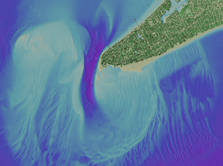
The Joint Airborne Lidar Bathymetry Technical Center of Expertise (JALBTCX) is a partnership in airborne coastal mapping and charting among the U.S. Army Corps of Engineers (USACE), U.S. Naval Oceanographic Office (NAVOCEANO), and the National Oceanographic and Atmospheric Administration. The JALBTCX mission is operations and research and development in airborne lidar bathymetry and complementary airborne coastal mapping and charting technologies. Over the past 25 years the partners have led the development of three airborne sensors. JALBTCX currently operates the second of those, the Compact Hydrographic Airborne Rapid Total Survey (CHARTS) system, in support of NAVOCEANO tactical charting and the USACE National Coastal Mapping Program (NCMP). USACE started the NCMP in 2004 to provide regional, re-occurring, high-accuracy, high-resolution elevation and imagery data to support regional sediment management. Over the life of the program, data products have evolved from basic elevation point clouds and image frames to high-end information products created by fusing data from the lidar and imagery sensors on-board CHARTS. These products support USACE navigation, environmental restoration, regulatory enforcement, asset management and emergency response activities in the coastal zone. Future development in products and sensors is focused on the Coastal Zone Mapping and Imaging Lidar (CZMIL), a new hardware and software development effort nearing flight tests.
Jennifer Wozencraft is a Research Physical Scientist in the Coastal and
Hydraulics Laboratory of the U.S. Army Corps of Engineers (USACE) Engineer Research and Development Center, currently detailed as Director of the Joint Airborne Lidar Bathymetry Technical Center of Expertise (JALBTCX). At the JALBTCX, she coordinates operations and research and development in airborne lidar bathymetry and complementary airborne technologies in support of the USACE, U.S. Naval Oceanographic Office, National Oceanic and Atmospheric Administration, and the U.S. Geological Survey. In addition to her directorial duties, she is manager of the USACE
National Coastal Mapping Program, which provides regional scale, re-occurring, engineering-accuracy elevation and imagery data to support USACE regional sediment management, navigation, environmental restoration, regulatory enforcement, asset management and emergency response activities in the coastal zone. The NCMPalso fosters development of new technologies for airborne coastal mapping and charting, and under this portion of the program Ms. Wozencraft manages development of the latest generation of airborne coastal mapping and charting systems, the Coastal Zone Mapping and Imaging Lidar, or CZMIL. Ms. Wozencraft has worked in the field of lidar bathymetry for the past 15 years, beginning with the USACE SHOALS program during her college years. She earned her bachelor's degree from the University of Alabama in mathematics and dance and her master's in marine sciences from the University of South Alabama.